
[36 Pa.B. 3844]
[Saturday, July 22, 2006]
[Continued from previous Web Page] 
E02-1520. Michael Joseph Development Company, 105 Bradford Road, Suite 310, Wexford, PA 15090. To place fill in wetlands in Harrison Township, Allegheny County, Pittsburgh ACOE District. (Freeport, PA Quadrangle N: 3.93 inches; W: 12.37 inches and Latitude: 40° 38` 48"--Longitude: 79° 42` 51"). To place and maintain fill in 0.46 acre of PEM wetlands and to place and maintain fill in 643.0 linear feet of a UNT to Little Bull Creek (TSF) for the purpose of constructing a Walmart Super Center as part of the redevelopment of the Highlands Mall. The project is located on the west side of Freeport Road (Route 28), approximately 800.0 feet northwest from the intersection of Freeport Road (Route 28) and Old Freeport Road. To compensate for the environmental impacts, the permittee will construct 0.55 acre of replacement wetlands (PEM/PSS) off site, relocate, reconstruct and maintain approximately 120.0 linear feet of watercourse below a new outfall structure onsite and restore approximately 600.0 linear feet of watercourse offsite.
Northwest Region: Watershed Management Program Manager, 230 Chestnut Street, Meadville, PA 16335-3481.
E20-542, Nye's Marina Service, Ltd., 12318 Conneaut Lake Road, Conneaut Lake, PA 16316. Nye's Marina Expansion, in Sadsbury Township, Crawford County, ACOE Pittsburgh District (Conneaut Lake, PA Quadrangle N: 19.2 inches; W: 5.7 inches).
The applicant proposes to conduct the following activities at Nye's Marina facility (Conneaut Lake, PA Quadrangle N: 19.2 inches; W: 5.7 inches) adjacent to and in Conneaut Lake approximately 0.2 mile west of the intersection of SR 18 and SR 322 in Sadsbury Township, Crawford, County: 1) to conduct maintenance dredging of sediment to an approximate normal water depth of 7 feet in the west marina area (approximately 1.7 acres and 6,458 cubic yards), east marina area (approximately 0.52 acres and 3,565 cubic yards) and eastern lakeshore area (approximately 0.46 acres and 2,052 cubic yards); 2) to expand the east marina area by excavating an approximately 0.54 acre area to a depth 10 feet (7,761 cubic yards) east of and adjacent to the existing east marina area; and 3) to operate and maintain existing and proposed marina areas. The project includes future maintenance dredging, creation of spoil areas on the marina property, operation and maintenance of existing docks in the marina and installation, operation and maintenance of docks in the east marina portion of the marina. Conneaut Lake is a perennial body of water classified as a HQ-WWF. The project proposes to temporarily impact 3.2 acres of Conneaut Lake and adjacent excavated areas.
Department of Environmental Protection, Bureau of Waterways Engineering, Water Management Program Manager, Rachel Carson State Office Building, 400 Market Street, P. O. Box 8554, Harrisburg, PA 17105-8554.
E4914-001, Department of General Services, Bureau of Engineering and Architecture, 18th and Herr Streets, Harrisburg, PA 17125, Shamokin Creek Flood Protection Project, Borough of Mount Carmel and Mount Carmel Township, Northumberland County, ACOE Baltimore District.
The permit is requested for a flood protection project with the following activates associated with the construction of the project in and along approximately 7,740 linear feet (~2.5 acres) of Shamokin Creek (perennial, WWF):
1. The upstream end of the project is on the east end of the Borough of Mount Carmel approximately 620-feet upstream of Pine Street. The upstream end of the project is a debris basin and open channel inlet. A rectangular concrete channel (16 feet wide) will run for 160 linear feet from the debris basin.
2. A 16-feet wide rectangular concrete box culvert will connect the new rectangular concrete channel to an existing concrete box culvert at Pine Street. This culvert will extend for a distance of 485 feet.
3. An existing concrete box culvert runs for a distance of 1,702 linear feet from Pine Street to Locust Street. This culvert was constructed in three sections from 1977 to 1987. Water Obstruction and Encroachment Permits 4977710, ENC49:17 and E49-111 were issued for this existing culvert. The existing culvert will become part of the overall flood protection project.
4. A rectangular concrete channel will be constructed from the existing culvert outlet at Locust Street to the football stadium on the west end of Mount Carmel. The channel will run for a distance of 4,929 linear feet in an overall stream length of 5,393 linear feet. The width of the concrete channel is 20 feet.
5. A precast concrete box culvert will replace the existing bridge at Walnut Street. The box culvert is 75 linear feet long with interior dimensions of 20 feet wide and 9 feet high.
6. A precast concrete box culvert will replace the existing bridge at Chestnut Street. The box culvert is 70 linear feet long with interior dimensions of 20 feet wide and 10 feet high.
7. A precast concrete box culvert will replace the existing corrugated metal pipe culvert at Market Street. The box culvert is 80 linear feet long with interior dimensions of 20 feet wide and 10 feet high.
8. A precast concrete box culvert will replace the existing masonry arch culvert at Hickory Street. The box culvert is 101 linear feet long with interior dimensions of 20 feet wide and 10 feet high.
9. The existing concrete box culvert at Vine Street will remain. The invert of this culvert will be paved with concrete for a length of 138 linear feet. The box culvert has interior dimensions of 20 feet wide and a minimum 10 feet high.
The project is located along Shamokin Creek (Mount Carmel, PA Quadrangle N: 8.9 inches, W: 5.5 inches) in the Borough of Mount Carmel and Mount Carmel Township, Northumberland County.
E4614-001, Department of General Services, Bureau of Engineering and Architecture, 18th and Herr Streets, Harrisburg, PA 17125, Ardsley Drainage Channel Flood Protection Project, Township of Upper Dublin, Montgomery County, ACOE Philadelphia District.
The permit is requested for a flood protection project with the following activates associated with the construction of the project in and along approximately 2,500 linear feet (~1.7acres) of the Ardsley Drainage Channel (intermittent, WWF):
1. The upstream end of the project is at Penn Street in Abington Township. The upstream end of the project connects to an existing elliptical concrete pipe under Penn Street. A concrete box culvert (10 feet wide) will run for 305 linear feet from the Penn Street pipe.
2. The concrete box culvert empties into a 10-foot wide rectangular concrete channel. This channel will extend for a distance of 340 feet to an area near the intersection of Spear Avenue and Avenue G. The channel transitions to a 14-foot width and continues for a distance of 188 feet to Avenue H.
3. The existing corrugated metal pipe arch under Avenue H will be replaced with a new concrete box culvert that is 14 feet wide. The new concrete box culvert is 63 feet long.
4. A rectangular concrete channel will be constructed from Avenue H to Avenue J. The channel will run for a distance of 172 linear feet. The width of the concrete channel is 10 feet.
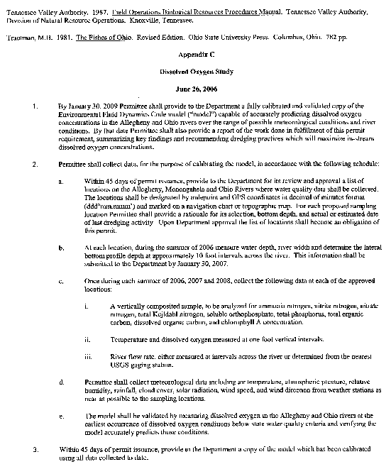
5. A precast concrete box culvert will replace the existing corrugated metal pipe under Avenue J. The box culvert also replaces a riprap lined channel between Avenue J and North Hills Avenue. The box culvert is 252 feet long with interior dimensions of 10 feet wide and 4 feet high.
6. A precast concrete box culvert will replace the existing box culvert under North Hills Avenue down to Fitzwatertown Road. The box culvert is 895 feet long with interior dimensions that vary between widths of 10 and 14 feet width depths between 4 feet and 3 feet 9 inches.
7. An existing concrete box culvert under Fitzwatertown Road will remain. The existing box culvert is 100 feet long.
8. A trapezoidal riprap channel will be constructed downstream of the existing Fitzwatertown Road culvert. The riprap channel will have a bottom width of 12 feet and a bank height of 5 feet. This channel will extend for a distance of 145 feet to the stream junction with Sandy Run.
The project is located along the Ardsley Drainage Channel (Ambler, PA Quadrangle N: 0.0 inch, W: 5.0 inches) in Upper Dublin Township, Montgomery County.
E3514-001, Department of General Services, Bureau of Engineering and Architecture, 18th and Herr Streets, Harrisburg, PA 17125, Meadow Brook Flood Control Project, City of Scranton, Lackawanna County, USACOE Baltimore District.
This permit is requested for a flood protection project in and along approximately 3,524 linear feet (approximately 4.5 acres) of Meadow Brook. Permit No. E35-356, which was previously issued for this work, inadvertently expired December 31, 2005. The project begins 180 feet upstream of Green Ridge Street (USGS ''Scranton'' Quadrangle, North 9.5 inches, West 3.2 inches) and extends to Meadow Brook's confluence with the Lackawanna River (USGS ''Scranton'' Quadrangle, North 9.0 inches, West 4.6 inches).
In November 2005, under a Federal contract, the United States Army Corps of Engineers (Corps) began construction of an earthen levee flood protection project along the east bank of the Lackawanna River. That work is scheduled to be complete in March 2007. Since the levee system will cross the Meadow Brook outfall, the pipe sections at the outfall of the Commonwealth's Meadow Brook project must be installed before the Corps can extend their levee across and beyond Meadow Brook. Therefore, it is imperative that the Meadow Brook project begins as soon as possible. Delays in starting construction of the Meadow Brook project will almost certainly result in delays and cost increases in the Corps project.
The following activities are associated with the Meadow Brook project:
* Remove existing culverts and stream enclosures along a 3,524-foot reach of Meadow Brook.
* Construct and maintain a 16-foot long concrete transition culvert between the upstream end existing culvert and a new 10-foot wide by 7-foot high concrete box culvert.
* Construct and maintain 1,806 linear feet of 10-foot wide by 7-foot high concrete box culvert.
* Construct and maintain 231 linear feet of 10-foot wide by 7-foot high concrete open channel.
* Construct and maintain a 14-foot-long concrete transition structure between the 10-foot wide by 7-foot high concrete open channel and a new 10.5-foot diameter concrete pipe culvert.
* Install and maintain 360 linear feet of 10.5-foot diameter concrete pipe culvert.
* Construct and maintain a 22-foot long concrete transition culvert between the 10.5-foot diameter concrete pipe culvert and a new 12-foot wide by 8.5-foot high concrete box culvert.
* Construct and maintain 188 linear feet of 12-foot wide by 8.5-foot high concrete box culvert.
* Construct and maintain a 22-foot long concrete transition culvert between the 12-foot wide by 8.5-foot high concrete box culvert and a new 12-foot diameter concrete pipe culvert.
* Install and maintain 814 linear feet of 12-foot diameter concrete pipe culvert. At pipe outlet, construct and maintain concrete end walls and a 53-foot long grouted R-7 riprap apron.
* Construct and maintain approximately 11 stormwater outfall penetrations varying in size from 18-inch diameter to 48-inch diamter at various locations along the flood control project.
Anticipated construction time is 18 months.
DAM SAFETY Central Office: Bureau of Waterways Engineering, 400 Market Street, Floor 3, P. O. Box 8554, Harrisburg, PA 17105-8554.
D35-001. Natural Lands Trust, Inc., 1031 Palmers Mill Road, Media, PA 19063. Plan for initial drawdown and stabilization of sediments within the impoundment created by Glenburn Pond Dam, located across Ackerly Creek (TSF). This work is considered Phase I of the eventual breach and removal plan and includes initial drawdown of the impoundment using siphons, redirecting Ackerly Creek to discharge to the center of the impoundment area, constructing a berm within the reservoir impacting approximately 0.9 acre for access and sediment management, and creating a spillway notch to reduce the spillway elevation and normal pool from 1,022.79 to 1,019.0. (Dalton, PA Quadrangle N: 3.4 inches; W: 3.0 inches) in Glenburn Township, Lackawanna County.
SPECIAL NOTICES
Reclamation of Abandoned Strip Mine Project; Washington, Jefferson County Knox District Mining Office: P. O. Box 669, 310 Best Avenue, Knox, PA 16232-0669, (814) 797-1191.
Under Act 181 of 1984, the Department of Environmental Protection solicits letters of interest from the landowners and licensed mine operators for the reclamation of the following abandoned strip mine project:
Project No. Municipality County Acres PBF 33990907.1 Washington Jefferson 15.0 Dale Hollobaugh, SMP No. 33990907, on the Steve Gertz and Gloria Austin et al properties requires backfilling and revegetation.
Letters of interest must be received by Javed I. Mirza, District Mining Manager, Department of Environmental Protection, P. O. Box 669, Knox, PA 16232, no later than 4:30 p.m., July 31, 2006, to be considered.
Telephone inquiries should be directed to Javed I. Mirza at (814) 797-1191.
[Pa.B. Doc. No. 06-1283. Filed for public inspection July 21, 2006, 9:00 a.m.]
No part of the information on this site may be reproduced for profit or sold for profit.This material has been drawn directly from the official Pennsylvania Bulletin full text database. Due to the limitations of HTML or differences in display capabilities of different browsers, this version may differ slightly from the official printed version.

